18 February 2017

The Grateful Dead and Jefferson Airplane at San Francisco's Golden Gate Park, Then & Now: 28 Sept 1975 and 18 February 2017

I read an article published by SFGate that contained 65 archival photographs of Golden Gate Park. One photo, in particular, caught my eye. It was a picture of the Grateful Dead at an outdoor concert in 1975. The information about the image stated that the concert took place at Speedway Meadow. I decided to go to Speedway Meadow in Golden Gate Park and identify the concert stage's location based on the topographical data shown in the photo. It took me a little while to conclusively determine where the concert took place on that cold, blustery Sunday forty-one years ago. Most band members are still alive; however, some musicians have died, and the bands are no longer active.

This was a free concert by the Grateful Dead and Jefferson Airplane. An estimated 40-50,000 people gathered at Lindley Meadow in Golden Gate Park on 28 September 1975. This was also the Grateful Dead’s first public performance in nearly a year.

The weather was chilly and overcast, but it did not dampen enthusiasm as
Jefferson Airplane mounted the stage to a standing hometown ovation and played their old favorites for the next two hours. "Don't anyone go away!" Paul Kantner shouted over the applause, "The Grateful Dead is coming on!"

Grateful Dead bassist Phil Lesh was the first to plug in and face the audience. The crowd roared its approval. Elsewhere onstage, pianist Keith Godchaux breathed into his cupped hands to keep them warm while his vocalist wife Donna smiled with the anticipation of singing some of the newer Dead songs. Behind them, drummers Mickey Hart and Bill Kreutzmann were warming up, as was Paul Kantner, rhythm guitarist. Then a leather-jacketed Jerry Garcia stepped forward and sent out a trademark guitar riff, marking the start of a great two-hour concert.


The Grateful Dead on stage at Lindley Meadow, Golden Gate Park, 28 September 1975; the view is looking west. 

Jerry Garcia and Phil Lesh in San Francisco's Haight-Ashbury District. Circa late 1960s.

Grace Slick and Jefferson Airplane at Golden Gate Park, 28 September 1975.
Golden Gate Park.
Latitude and longitude coordinates (37.7692, -122.4862) are shown on this Google Earth map. They show the approximate location of the concert stage sited on Lindley Meadow. 
 THEN  The Grateful Dead on stage in 1975. This is the photo that was published in SFGate. The view is looking north. 
NOW  The approximate location of the concert stage. 

 THEN  Paul Kantner of Jefferson Airplane on stage in 1975. The view is looking northeast.
 NOW  The approximate location of the concert stage. 
 THEN  The Grateful Dead on stage in 1975. The view is looking east. 
NOW  The approximate location of the concert stage. 


"A camera is a tool for learning how to see without a camera.” Dorothea Lange 

"Photography has not changed since its origin except in its technical aspects, which for me are not important." Henri Carter-Bresson

"There are always two people in every picture: the photographer and the viewer." Ansel Adams

"The important thing is not the camera but the eye." Alfred Eisenstaedt


The first volume of the San Francisco Bay Area Photo Blog contains galleries of photographs posted on the Internet between 2002 and 2011. Click Here to view these photo galleries.

Panasonic GX7 camera body mounted with a Panasonic 14-42mm lens was used to take these photographs.

Question or comment? I may be reached at neil@mishalov.com

12 February 2017

San Francisco Then & Now – The Old Mint: 12 February 2017 & 4 March 2017

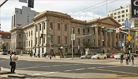
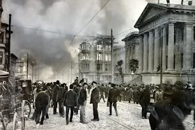
The San Francisco Mint was opened in 1854 to manufacture gold coins from gold bullion produced during the California Gold Rush. The mint soon needed a bigger building to process and store the large quantities of gold bullion it was receiving. In 1869 the mint moved to a larger building located at 88 5th Street at Mission Street. That building is now known as the Old Mint, and it is one of the few buildings that survived the 1906 San Francisco earthquake and fire. The damage caused to San Francisco by the 18 April 1906 earthquake pales in comparison to the devastation caused by the fifty-two fires that burned through the city for more than three days. There were 3,000 to 4,000 people killed, and 28,000 buildings were destroyed, most by fire. 

The Old Mint was designed by Alfred B. MullettHe planned a building that was built around an enclosed central courtyard that contained a water well, a feature that helped save the building during the fires of April 1906. The building was constructed on a concrete base, the objective of which was to thwart tunneling into the mint's vaults. At the time of the 1906 fire, the mint held $300 million dollars in gold, a third of the United States’ gold reserves. Heroic efforts by the employees of the mint saved the building and the gold bullion stored in its vaults. The mint resumed operation soon thereafter. The Old Mint continued to function until 1937 when the currently operating mint was opened on Hermann Street in San Francisco. 


    The Old Mint THEN: 1885. Note the horse-drawn streetcar. The view is looking southwest. Click on the image to see the full-size photograph.

    The Old Mint NOW: 12 February 2017Click on the image to see the full-size photograph.

 The Old Mint THEN: 18 April 1906. The view is looking southeast

 The Old Mint  NOW: 12 February 2017Click on the image to see the full-size photograph.

The Old Mint sits forlornly amidst total devastation after it survived both the earthquake and fire. This picture was taken soon after the 18 April 1906 earthquake and fire. The camera was attached to a kite; the view is looking northwest. Click on the image to see the full-size photograph.


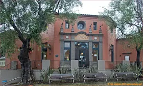
This photo was taken outside the Old Mint on 4 March 2017. Click on the image to see the full-size photograph.


This photo was taken inside the Old Mint on 4 March 2017. Click on the image to see the full-size photograph.


This photo was taken inside the Old Mint on 4 March 2017. Click on the image to see the full-size photograph.


This photo was taken inside the Old Mint on 4 March 2017. Click on the image to see the full-size photograph.


This photo was taken inside the Old Mint on 4 March 2017. Click on the image to see the full-size photograph.


This photo was taken inside the Old Mint on 4 March 2017. Click on the image to see the full-size photograph.


"A camera is a tool for learning how to see without a camera.” Dorothea Lange 

"Photography has not changed since its origin except in its technical aspects, which for me are not important." Henri Carter-Bresson

"There are always two people in every picture: the photographer and the viewer." Ansel Adams
"The important thing is not the camera but the eye." Alfred Eisenstaedt


The first volume of the San Francisco Bay Area Photo Blog contains galleries of photographs that were posted on the Internet between 2002 and 2011. Click Here to view these photo galleries.

Panasonic GX7 camera body mounted with a Panasonic 14-42mm lens was used to take these photographs.

Question or comment? I may be reached at neil@mishalov.com

11 February 2017

San Francisco Then & Now – The N-Judah light-rail line: 11 February 2017

The N-Judah Muni Metro light-rail line runs along Judah Street in the Sunset District for much of its length; it is named after railroad engineer Theodore Judah. The N-Judah line connects downtown San Francisco to the Cole Valley and Sunset neighborhoods. The line ends at the Pacific Ocean. It is the busiest light-rail line in the Muni Metro system; it served an average of 41,439-weekday passengers in 2013. The N-Judah line is also the only Muni Metro light-rail line that passes through the Sunset Tunnel. The N-Judah line began operation as a streetcar line in 1928 and was converted to a light-rail transportation system with the opening of the Muni Metro system in 1980.

The below photos were taken in the Inner Sunset neighborhood
The N-Judah Line NOW: 11 February 2017. This two car N-Judah light-rail vehicle is about to leave Irving Street and travel south on 9th Avenue for just one block. After which, the N-Judah light-rail turns west, onto Judah Street, and travels to the end of the line at Ocean Beach, and the Pacific Ocean.

The N-Judah Line THEN: 1978. This streetcar is heading west on Irving Street. It is about to turn south onto 9th Avenue. 
The N-Judah Line THEN: 1978. This streetcar is heading south on 9th Avenue. Golden Gate Park is visible in the background. 

The N-Judah Line NOW: 11 February 2017. This two-car light-rail vehicle is heading south on 9th Avenue. 

The N-Judah Line THEN: 1975. This streetcar headed south on 9th Avenue for one block before it is about to turn west onto Judah Street. 

The N-Judah Line NOW: 11 February 2017. This two-car light-rail vehicle is heading south on 9th Avenue just before it is about to turn west onto Judah Street and continue to Ocean Beach, the end of the line. 

The distance traveled was approximately 5.8 miles (9.3 kilometers). Mile markers are displayed on the GPS-generated track. The cumulative elevation gain was about 374 feet (114 meters), the cumulative elevation descent was 581 feet (177 meters). Click on the image to see the full-size map.

"A camera is a tool for learning how to see without a camera.” Dorothea Lange 

"Photography has not changed since its origin except in its technical aspects, which for me are not important." Henri Carter-Bresson

"There are always two people in every picture: the photographer and the viewer." Ansel Adams
"The important thing is not the camera but the eye." Alfred Eisenstaedt


The first volume of the San Francisco Bay Area Photo Blog contains galleries of photographs that were posted on the Internet between 2002 and 2011. Click Here to view these photo galleries.

Panasonic GX7 camera body mounted with a Panasonic 14-42mm lens was used to take these photographs.

Question or comment? I may be reached at neil@mishalov.com

09 February 2017

Rainy day photos of Berkeley, California: 8 & 9 February 2017


Rain, beautiful rain... A house on Josephine Street, North Berkeley. Click on the image to see the full-size photograph.
 Monterey Market is located on Hopkins Street, North Berkeley. Click on the image to see the full-size photo.
The North Berkeley Branch of the Berkeley Public Library is located on The Alameda. Click on the image to see the full-size photograph.
 Cedar Grocery Market is located on Cedar Street at California Street, North Berkeley. Click on the image to see the full-size photo.
 The Berkeley Cheese Board Pizza Collective is located on Shattuck Avenue, North Berkeley. Click on the image to see the full-size photograph.
 The bread and pastry area of the Berkeley Cheeseboard Collective in North Berkeley. Click on the image to see the full-size photo.
 The Hopkins Street shopping area, North Berkeley. Click on the image to see the full-size photograph.
 The original Peet’s Coffee Shop is located at the corner of Vine Street and Walnut Street, North Berkeley. Click on the image to see the full-size photo.
 Berkeley Natural Grocery is located on Gilman Street in the Westbrae area of Berkeley. Click on the image to see the full-size photograph.

"A camera is a tool for learning how to see without a camera.” Dorothea Lange 

"Photography has not changed since its origin except in its technical aspects, which for me are not important." Henri Carter-Bresson

"There are always two people in every picture: the photographer and the viewer." Ansel Adams
"The important thing is not the camera but the eye." Alfred Eisenstaedt


The first volume of the San Francisco Bay Area Photo Blog contains galleries of photographs that were posted on the Internet between 2002 and 2011. Click Here to view these photo galleries.

An Olympus TG-4 camera was used to take these photographs.

Question or comment? I may be reached at neil@mishalov.com